The United States is known for its beautiful landscapes and mountains that offer great opportunities for climbing lovers.
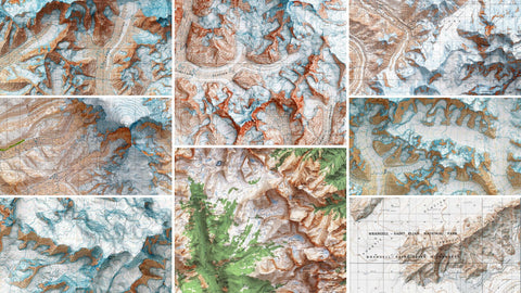
We’ve ranked the highest US peaks and created shaded relief maps—originally from USGS sources in the ’60s–’80s—that we digitally restored.
Let’s dive into the top 10!
10. Mount Hunter
-
Elevation: 4 444 m / 14 573 ft
-
The place: located within the Denali National Park in Alaska, it is the third highest peak in the Alaska Range.
-
Backstory: the mountain's native name is Begguya, meaning ‘Denali's child’.
In 1903, Robert Dunn, reporter of the "New York Commercial Advertiser," with F. A. Cook, named a high mountain "Mount Hunter," in honor of his aunt Anna Falconnet Hunter, 1885-1941, who financed his trip.

Detail from:
Taalketna, Alaska series, 1:250000 scale. Mapped, edited and published by the U.S. Geological Survey 1973.
Source: USGS.

Detail from:
Mt Foraker, 1:63360-scale Quadrangle for Talkeetna D-3, USGS, 1963.
Source: USGS.
9. Mount Bear
-
Elevation: 4 521 m / 14 833 ft
-
The place: high, glaciated peak in the Saint Elias Mountains of Alaska. It's situated inside the Wrangell-Saint Elias National Park.
-
Backstory: though little-known, Bear lies in Wrangell–St. Elias—one of the first areas geologists mapped in the late 1950s .

Detail from:
Mt Bear, 1:63360-scale Quadrangle for McCarthy B-1, USGS, 1966.
Source: USGS.

Detail from:
Mc Carthy, Alaska Series, 1:250000 scale. Mapped, edited and published by the U.S. Geological Survey 1980.
Source: USGS.
8. Mount Hubbard
-
Elevation: 4 551 m / 14 951 ft
-
The place: located on the Alaska/Yukon border, is one of the major mountains of the Saint Elias Range.
-
Backstory: Mount Hubbard was named in 1890 by the U.S. Geological Survey in honor of Gardiner Greene Hubbard, the first president of the National Geographic Society. Hubbard was also the father-in-law of Alexander Graham Bell, inventor of the telephone.

Detail from:
Mount Saint Elias, 1:250000 scale. Mapped, edited and published by the U.S. Geological Survey 1966.
Source: USGS.
7. Mount Fairweather
-
Elevation: 4 671 m / 15 325 ft
-
The place: known as Tsalxhaan in Tlingit, sits on the Alaska–British Columbia border within the Saint Elias Mountains.
-
Backstory:The peak gained its name on May 3, 1778, when Captain James Cook sighted it under unusually clear skies—a rare respite in an otherwise stormy region. He baptized it “Fairweather”, though visibility is often obscured in foul weather.

Detail from:
Mt Fairweather, 1:63360-scale Quadrangle for Mount Fairweather D-5, USGS, 1966.
Source: USGS.

Detail from:
Mt Fairweather (Alaska - Canada), Alaska Series, 1:250000 scale. Mapped, edited and published by the U.S. Geological Survey 1979.
Source: USGS.
6. Mount Sanford
-
Elevation: 4 949 m / 16 237 ft
-
The place: is a colossal shield volcano, located in the western Wrangell Mountains within Wrangell–St Elias National Park, eastern Alaska.
-
Backstory:The mountain was named in 1885 by U.S. Lieutenant Henry T. Allen, who named it after his great-grandfather Reuben Sanford.The first ascent was made on July 21, 1938, by Terris Moore and Bradford Washburn, who skied the North Ramp Sheep Glacier route—a moderately technical glacier climb classified as Alaska Grade 2.

Detail from:
Gulkana, Alaska Series, 1:250000 scale. Mapped, edited and published by the U.S. Geological Survey 1969.
Source: USGS.

Detail from:
Mt Sanford, 1:63360-scale Quadrangle for Gulkana A-1, USGS, 1964.
Source: USGS.
5. Mount Blackburn
-
Elevation: 4 996 m / 16 390 ft
-
The place: formed 3.4–5 million years ago, is a shield volcano in Alaska’s Wrangell Mountains. Its core consists of granite intruded into andesite flows, later heavily eroded and glaciated.
-
Backstory:lieutenant Henry T. Allen named Mount Blackburn in 1885 after U.S. Senator Joseph C.S. Blackburn. The highest point—the west summit—was reached in 1958 by Bruce Gilbert, Dick Wahlstrom, Hans Gmoser, Adolf Bitterlich, and Leon Blumer via the North Ridge, marking the true first ascent of the peak.

Detail from:
Mc Carthy, Alaska Series, 1:250000 scale. Mapped, edited and published by the U.S. Geological Survey 1980.
Source: USGS.

Detail from:
Mt Blackburn, 1:63360-scale Quadrangle for McCarthy C-7, USGS, 1966.
Source: USGS.
4. Mount Bona
-
Elevation: 5 044 m / 16 550 ft
-
The place: ice-covered stratovolcano in the Saint Elias Range,in eastern Alaska. Bowl-shapes and glaciers (Klutlan, Churchill) dominate its profile; soils are minimal, largely on moraines and ice margins.
-
Backstory: first climbed on July 2 1930 by Carpé, Moore, and Taylor. Named in 1897 by the Duke of the Abruzzi after his yacht. Its last eruption was around 847 CE, making it Alaska's highest volcano.

Detail from:
Mc Carthy, Alaska Series, 1:250000 scale. Mapped, edited and published by the U.S. Geological Survey 1980.
Source: USGS.

Detail from:
Mt Bona, 1:63360-scale Quadrangle for McCarthy B-2, USGS, 1966.
Source: USGS.
3. Mount Foraker
-
Elevation: 5 304 m / 17 400 ft
-
The place: this granitic massif in the Alaska Range towers above Kahiltna Glacier. Its slopes support alpine icefields, moraines, and thin soils typical of high glacial terrain.
-
Backstory: named after U.S. Senator Foraker. Its North Peak was first climbed on August 6 1934; the main summit followed four days later via the west ridge by Houston, Brown & Waterston.

Detail from:
Taalketna, Alaska series, 1:250000 scale. Mapped, edited and published by the U.S. Geological Survey 1973.
Source: USGS.

Detail from:
Mt Foraker, 1:63360-scale Quadrangle for Talkeetna D-3, USGS, 1963.
Source: USGS.
2. Mount Saint Elias
-
Elevation: 5 489 m / 18 009 ft
-
The place: it straddles the Alaska–Yukon border in the Saint Elias Mountains. A tectonic marvel formed by subduction of the Yakutat microplate, it's capped by massive glaciers and steep, rapidly eroding slopes . Soils are rudimentary—thin, coarse sediments and glacial deposits.
-
Backstory: first ascended in 1897 by the Duke of the Abruzzi post-Louisiana expedition. Known as Boundary Peak 186 in US–Canada survey systems.

Detail from:
Mt Saint Elias, 1:63360-scale Quadrangle for Mount Saint Elias A-8 and B-8, USGS, 1985.
Source: USGS.

Detail from:
Mount Saint Elias, 1:250000 scale. Mapped, edited and published by the U.S. Geological Survey 1966.
Source: USGS.
1. Denali
-
Elevation: 6 190 m / 20 310 ft
-
The place:North America’s tallest mountain at 6,194 m. A massive granitic pluton pushed up by Pacific Plate subduction along the Denali Fault system . Features extensive icefields and glaciers, permafrost down to ~30 m, and varied soils from loamy boreal soils to alpine silty tills.
-
Backstory: named “Denali”—“the High One”—by indigenous people; renamed McKinley in 1896, restored to Denali officially in 2015. First recorded ascent in 1913 by Hudson Stuck’s team. The region's geological record extends to 11,000 BC; dynamic tectonics shaped modern landforms.

Detail from:
Denali/Mt McKinley, 1:63360-scale Quadrangle for Mount McKinley A-3, USGS, 1964.
Source: USGS.

Detail from:
Denali/Mt McKinley, 1:250000 scale. Mapped by the Geological Survey and the Museum of Science, published by the Geological Survey. USGS, 1982.
Source: USGS.
Comments (0)
There are no comments for this article. Be the first one to leave a message!