


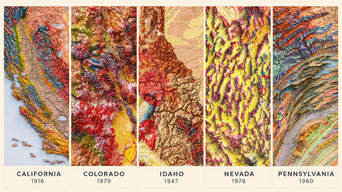
Geological maps combine scientific information with visual appeal. Their colors and shapes describe the structure of a landscape.
A geological map shows the distribution of rocks and sediments at or near the surface. Colors and symbols distinguish units by age and composition, while lines indicate contacts, faults, and other structures.
Our versions add shaded relief to historical cartography: a digital technique that uses light and shadow to highlight mountains, valleys, and plains. The result creates a three-dimensional effect, even though the print is flat on paper.
We have selected five geological maps from our collection, outlining their features and some of their history.
1. California, 1916
California’s elongated shape encompasses a wide range of landscapes, from the coastal ranges through the Central Valley to the Sierra Nevada. In the 1916 geological map of California, geological divisions appear alongside landforms highlighted by shaded relief.
Its appeal lies in the contrast between broad, flat areas and mountainous terrain. The date adds historical interest: the map documents how the state’s geology was represented in the early twentieth century.
A suitable choice for anyone looking for a recognizable subject with plenty of detail to explore.
2. Colorado, 1979
Colorado comprises three major regions: the Great Plains to the east, the Rocky Mountains in the center, and the plateaus to the west. This division makes the relationship between geology and landforms particularly interesting.
In the 1979 geological map of Colorado, shading emphasizes the mountain ranges and their transition into the surrounding areas. The geological colors provide additional information about the distribution of rocks.
It is a good choice for anyone who loves the Rocky Mountains and wants a different view of the state from a conventional geographic map.

3. Idaho, 1947
Two important features of Idaho’s geology are its large central batholith, composed mainly of granitic rocks, and the Snake River Plain, a region across the southern part of the state with a long volcanic history.
The 1947 geological map of Idaho was prepared by Clyde P. Ross and J. Donald Forrester and published by the USGS. The shaded relief version allows viewers to compare the distribution of geological units with the shapes of the landscape.
Of these five maps, it is an interesting option for anyone looking for a less familiar subject with considerable geological variety.

4. Nevada, 1978
Nevada is characterized by a succession of mountain ranges and basins. Almost the entire state lies within the Basin and Range province, where the stretching of the Earth’s crust has produced this distinctive alternation of high and low terrain.
In the 1978 geological map of Nevada, shaded relief highlights this repeated structure. The geological mapping shows the differences between the formations that make up the terrain.
This succession of mountain ranges gives the map a distinctive graphic character, making it appealing even to those choosing it primarily as wall decor.

5. Pennsylvania, 1960
Pennsylvania displays a different pattern from the western states. In the Appalachian Ridge and Valley region, long ridges and valleys follow folded rock layers that have eroded at different rates depending on their resistance.
In the 1960 geological map of Pennsylvania, these structures are worth a closer look: the geological bands and shaded relief help reveal how the landscape is organized.
A choice for anyone who prefers a composition of elongated bands, curves, and fine detail.

Which One Should You Choose?
California and Colorado suit those looking for strong contrasts between mountains and plains. Idaho combines a less familiar subject with varied geology. Nevada stands out for its repeated mountain ranges, while Pennsylvania is distinguished by the patterns of its Appalachian bands.
All five combine historical cartography with digitally shaded relief: decorative prints that also offer a different way to understand the landscape.
Comments (0)
There are no comments for this article. Be the first one to leave a message!