MA CON GRAN PENA LE RECA GIÙ
If you studied geography at any Italian school, you’ll know that this is the “magic formula” for memorizing the names of the Italian Alps: Marittime, Cozie, Graie, Pennine, Lepontine, Retiche, Atesine, Carniche, Giulie.
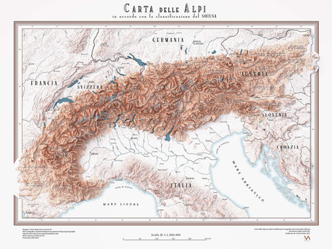
It was this very childhood mnemonic that inspired us to create a new map of the Alps—one that reflects the updated geographic classification adopted in 2005, known as the International Standardized Mountain Subdivision of the Alpine System (SOIUSA).

The traditional division of the Alps was introduced in 1926 by the Italian National Geographic Committee. Although it was one of the first schemes to consider the entire Alpine territory (and not just those parts within national borders), the SOIUSA author argues that it still carries an Italian-centric perspective, and for that reason has been regarded as outdated in recent decades.
The new classification strives to reconcile the various Italian, French, Swiss, Austrian, and Slovenian grouping systems. It splits the Alpine system into the Western Alps and the Eastern Alps, which are further subdivided into the North‑Western, South‑Western, Central‑Eastern, North‑Eastern, and South‑Eastern Alps.

Returning to our map, we drew inspiration from the U.S. Geological Survey maps of the 1960s, where elevation contours actually form the ground color, and lakes are rendered with a series of concentric-line buffers.
For the coastline, we applied a buffer that highlights the shore with a gentle gradient shifting from deep blue to white. Finally, rivers were drawn with a tapering effect that makes them wider as they flow away from their sources.
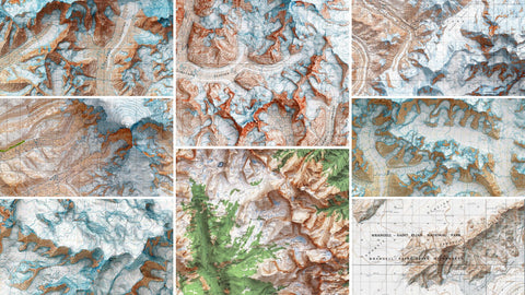
This map aims to be a meeting point between modern techniques and the antique cartographic aesthetic, with a strong emphasis on clarity and legibility. I hope this attention to details is evident in the selection of zooms below.


Commenti (0)
Non ci sono commenti per questo articolo. Sii il primo a lasciare un messaggio!