Have you ever wondered about the fascinating world of maps dedicated to Sicily? Well, buckle up because we are about to take you on a quirky journey through the different shaded relief maps available on our site. Let's dive in!
What's the Deal with Sicily Maps?
So, why are we dedicating a whole blog post to Sicilian maps? Well, the answer is simple - we are currently in Sicily, more specifically in Palermo. Seizing the opportunity of being in Sicily, let's talk about the unique maps dedicated to this beautiful island.
The Soil Map of 1967

First up, we have the Soil Map of Sicily published in 1967. This map provides valuable insights into the composition of the soil in Sicily. Created with precision and care, this map is a treasure trove of information for agricultural enthusiasts.The map was crafted by Gian Pietro Ballatore and Giovanni Fierotti, a two important university professors prominent for innovations in the technical-agricultural field.
Published in 1967 by Istituto di Agronomia Generale e Coltivazioni Erbacee of University of Palermo, the Soil Map of Sicily stands as a testament to excellence in soil cartography. This map not only provided details on soil composition, but also offered an overview of the various regions of Sicily, making it a valuable tool for anyone interested in agriculture or the geography of the region.
Moreover, the map was published with contributions from the University of Palermo, the Institute of General Agronomy and Herbaceous Cultivation, the Union of Chambers of Commerce, Industry and Agriculture of the Sicilian Region, and the Committee for the Soil Map of Italy. This underscores the importance and relevance of this map, which has been recognized and supported by several prestigious institutions.
The 1967 Soil Map of Sicily is a piece of history, proposed in shaded relief is a beautiful map that rediscovers itself as an object of art and decor.
The Topographic Map of 1943

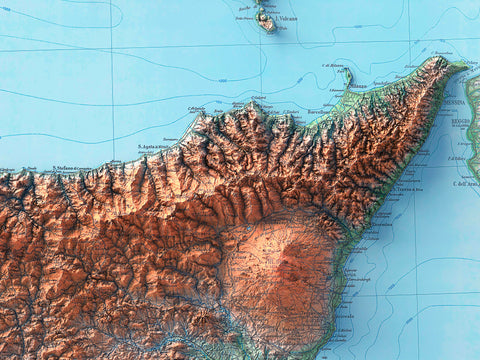
Continuing our journey through the historical maps of Sicily, we come to the Topographic Map of 1943. This map, available on our shop, highlights the intricate details of Sicily’s terrain, showcasing its diverse landscapes and geographical features. It is a true masterpiece from the past!
The map was prepared and published by the Military Geographical Institute of Florence in 1943. This institute has a long history of producing great maps, and is known for its huge catalog. The 1943 Topographic Map of Sicily is an excellent example of their work.
Every detail on the map has been carefully studied and represented, making this map not only a useful tool for understanding the geography of Sicily, but also a work of art that captures the essence of the Sicilian landscape as it was in 1943 (but still valid today).
The map has been digitally restored to remove imperfections due to poor preservation and natural aging, to restore the image to its original appearance and improve readability.
The Hypsometric Maps: Geo, Spectral, Viridis, and White

Finally, we turn our attention to the Ipsometric Maps - Geo, Spectral, Viridis, and White, available on VizCart. These maps provide a unique perspective on Sicily’s elevation and relief, using different color palettes to represent the data. Every map tells the same story, using the same tool, the colors, but sometimes highlighting different details.
Hypsometric maps, also known as Elevation maps, are a type of topographic map that uses graded color changes to represent changes in elevation. They offer a visually intuitive way to understand the terrain and are particularly useful for understanding large-scale landscape patterns. The Geo, Spectral, Viridis, and White maps each use a different color scheme to represent elevation data.
The Geo map uses a color scheme that is similar to natural colors, making it intuitive and easy to understand. The Spectral and Viridis maps use a color scheme that spans a wide range of colors, making it possible to distinguish a large number of elevation levels. Finally, the White map uses a grayscale color scheme, providing a minimalist and elegant representation of the data. Each of these maps offers a unique perspective on Sicily’s topography, allowing us to appreciate the island’s diverse landscapes and geographical features.
Whether you’re interested in the towering peaks of Mount Etna, the rolling hills of the Sicilian hinterland, or the coastal plains along the Mediterranean Sea, these maps offer a fascinating insight into Sicily’s physical geography.
As we wrap up our exploration of Sicilian maps, we can't help but tease a future blog post dedicated to Sardinia. Not because we are heading there next, but because it's the other great Italian island waiting to be discovered. Stay tuned for more quirky adventures!


Commenti (0)
Non ci sono commenti per questo articolo. Sii il primo a lasciare un messaggio!